The Congo Basin is home to the world’s second largest rainforest and is a carbon store of global significance. It is under severe pressure from industrial logging and clearance for agro-industry, but is home to an estimated 50 million forest-dependent people, including some 150 different ethnic groups – some of the poorest and most marginalized people on the planet.
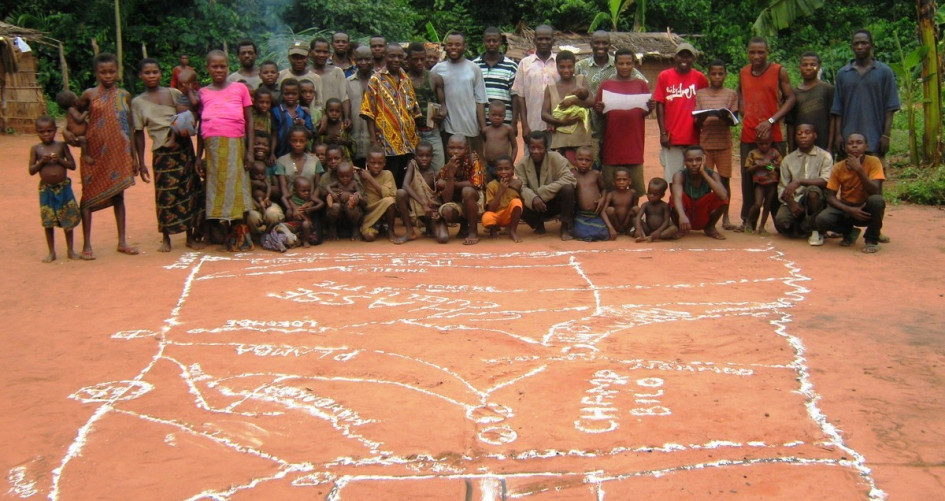
MappingForRights is a ground-breaking project of the Rainforest Foundation UK and its local partners in the Congo Basin region that aims to help forest peoples counter harmful extractive industry and advocate for legal reforms. As well as providing communities with accurate printed maps of their lands, it is also an online platform allowing indigenous community leaders, decision-makers and NGOs in the region easy access to accurate geographical information about community lands and other users and allocations of the forests.
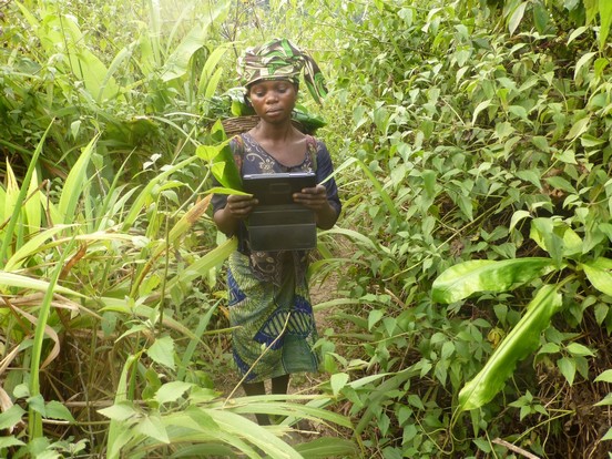
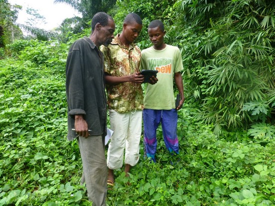
The system is based on enabling communities themselves to map and monitor their lands through low-cost, transferable technologies and making this data available to authorized users through an online interactive map.
In 2015, the project was further strengthened with the launch of ForestLink, a breakthrough forest monitoring system that allows remote communities to capture and transmit alerts on illegal logging and other forms of forest destruction in real-time – even in areas where there are no telecommunication networks.
Key facts
- A real-time alert on illegal logging from anywhere in the Congo Basin can be sent to a central database for as little as two cents, less than a text message.
- By 2017 it is expected that more than 700 communities in the Congo Basin would have mapped their lands through the MappingForRights programme.
- Up to six million hectares of forest community land will be mapped and uploaded to the platform by 2017.
The problem
In general, the laws of Congo Basin countries give the State overall ownership of all forest land. Indigenous peoples and local communities have virtually no formal or legally recognized control of the lands they traditionally occupy, though they are sometimes permitted to use the land. Today, much of the forest in the region has been allocated for logging, industrial agriculture and mining concessions, or reserved for strict wildlife conservation.
As tropical forests come under increasing pressure from agricultural conversion, unsustainable timber extraction and energy needs, the rights of forest dwellers are often ill-defined or becoming gradually eroded. Underlying this marginalization is often a lack of reliable and transparent information on their use, ownership and possession of the forest. Often, communities are either completely absent from key official data, such as forest usage maps, or information is inaccurate or not publicly available.
The solution
There is significant evidence that securing community rights to land and resources is one of the most effective ways to reduce poverty, preserve biodiversity, halt deforestation and reduce the harmful effects of climate change.
Geographical information generated by civil society organizations in the Congo Basin is collated in a repository web platform – www.MappingForRights.org – in order to facilitate access to a range of information showing customary occupation, as well as use of land and resources by forest communities. The visualization of this data can help to engage policy-makers, the private sector and the international community in a vital step towards changing policy and developing programmes that help secure local communities’ rights.
MappingForRights literally puts communities in the Congo Basin on the map by providing them with the technology and know-how to produce highly detailed digital maps of their traditional lands and resources that are used to claim land rights and challenge harmful projects. It then makes these community maps available and analyzable (including overlaying with other layers, such as deforestation maps, land use and designation etc.) through an online GIS interface.
The ForestLink system allows forest peoples the opportunity to send near-instantaneous, highly geographically accurate reports of illegal felling of trees, such as by timber or palm oil companies, from anywhere in the world, even where there is no mobile, phone or internet connectivity. Information on illegal activity in the forest can now be collected using a tablet computer or smartphone and then transmitted to an online map via a satellite modem transmitter in as little as 20 seconds – costing around the same as a standard text message. The live incident reports show where urgent action is required to prevent deforestation.
Helping the planet
The engagement of forest-dependent communities in direct 'crowd-sourced' real-time forest monitoring potentially transforms the way that forest illegalities are monitored and enforced. The location and type of reported infractions potentially becomes much more transparent and open to scrutiny – leading to more targeted and effective forest protection measures.
Helping people
Communities have full control over the entire mapping process from deciding what to map, collection and validation of the data and ultimately putting the maps to use for protecting their rights and traditional forests. Specific attention is paid to ensure the full representation and involvement of marginalized groups, including indigenous peoples and women who often have a higher dependence on the forest and suffer disproportionately from its destruction.
An icon-based system, which communities themselves can design, allows even illiterate people to collect and share highly detailed information about their lands and threats to these areas. The apps can also be downloaded to most Android mobile phone devices, whose use in many tropical forest countries has grown exponentially in recent years.
The programme is bringing the cost of large-scale on-the-ground tenure mapping within the budgets of the organizations responsible for developing and administering forest-related programmes. For example, the introduction by Rainforest Foundation UK of mobile mapping laboratories staffed by GIS technicians and mapping facilitators has reduced the cost from around USD 4.50 per hectare to as little as USD 1 per hectare, or an average of just USD 900 per village.
The Rainforest Foundation is about to trial a ‘payment for performance’ system whereby communities could be rewarded for verified illegal logging alerts using emerging mobile banking services, as part of efforts to ensure sustainability beyond project-specific funding.
Spillover effect
Building on the MappingForRights experience in the Congo Basin, the Rainforest Foundation UK recently undertook a year-long study concerning the feasibility of establishing a pan-tropical community mapping and monitoring facility. A consultation of more than 70 indigenous peoples’ organizations and NGOs in Asia, South America and Mesoamerica produced an overwhelmingly strong and clear demand for such a tool.
On the basis of the findings, the Rainforest Foundation has designed a system that can be configured as a network of autonomous but linked online geographical databases that can be used for territorial protection, forest monitoring and interface with governmental authorities and the private sector, while permitting aggregation of mapping information at larger scales. A two-year pilot phase is envisaged in which four to six pilot community mapping platforms will be established in different geographical settings under threat from tropical deforestation and the appropriate governance structure developed.


Images owned by the activity partners, all rights reserved.