There is nowhere on Earth facing the effects of climate change more profoundly than the Arctic. Warming quicker than anywhere else on the planet, its year-round temperature average is set to warm 4℃ by 2050. The region’s permafrost is thawing quicker than ever before, and by 2050 Arctic sea ice is predicted to have melted completely during summer months.
This was in evidence in the winter of 2010, when Arctic ice melt hit unprecedented levels, affecting the lives of the population of Nain, a town on the western shore of Nunatsiavut, the first Inuit region in Canada to achieve self-governance and one that spreads over more than 72,000 sq km.
“Instead of snow, there was rain most of February as the temperature was above freezing,” says Trevor Bell, a geographer with Memorial University in St. Johns, Newfoundland, and one of the founders of SmartICE. “The ice that had formed turned to slush and thinned and this had severe impacts on people traveling on the ice, hunting, harvesting and gathering firewood, so it really had a big impact.”
With the science making clear that warmer temperatures were going to become more common, the Nunatsiavut Government, began looking for ways to use technology to adapt to the effects of climate change, and, with Bell’s help, SmartICE was created.
SmartICE’s technology comprises of two different types of sensor: SmartBUOYs, which are 8-feet long stationary devices that are inserted into the ice to measure thickness, air temperature, snow, ice and water. Combined, these measurements create a temperature profile of each section and determine ice thickness. This data is transferred to satellites every day and made available at Siku.org, while maps are created and posted in local shops and community centres.
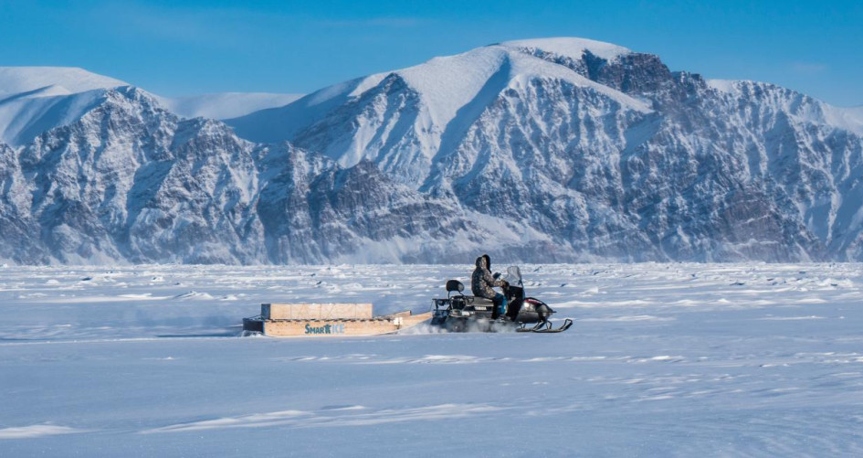
The SmartQAMUTIK is a sled-based sensor that is towed behind a snowmobile and provides real-time ice and snow thickness measurements to the operator, who will take a trip at least once a week and means the community can get the latest information on route safety.
SmartICE has now expanded into a non-profit social enterprise that develops climate change adaptation tools and services to deliver an operational service generated by Inuit for coastal communities and industries across the Arctic. Since 2017,it has partnered with more than 30 communities across Inuit Nunangat and northern territories and now has 25+ employees (full and part time), 40 per cent of which are Indigenous. Northern operation centres have been established in Nain, Nunatsiavut, Pond Inlet and Gjoa Haven, Nunavut.
“This technology is there to augment – not replace – existing Inuit knowledge about safe ice travel,” Bell says.
“This local knowledge has been passed down from generation to generation and includes techniques for checking sea ice depth with a harpoon and how dark clouds and mist signify open water and possible thin ice ahead. “Inuit have lived in these regions for millennia, but never had the need to write their knowledge down – it would have always been passed down orally,” he adds.
And while much of the Arctic has been mapped, it is often targeted at shipping companies, highlighting shipping routes and ignoring the Arctic communities who depend on knowledge of the ice for their livelihoods.
Andrew Arreak is SmartICE’s Regional Operations Lead in the Qikiqtaaluk Region and a founding member of Ikaarvik, the Arctic Inspiration Prize winning organization that mentors and supports Indigenous youth to be the bridge between research and their communities.
“Local people are aware of climate warming as they are out there the majority of the time and they don’t need an outsider to tell them the climate is changing,” Arreak says. “We use the ice to travel on, and it is part of who we are, and we would like to know the ice conditions in real time [using the SmartICE technology] as well as relying on our local knowledge.”
The technology – both the SmartICE devices and the online repository of maps and best practice on the ice – ensures that the local Inuit knowledge will be preserved for future generations. “A lot of the younger generation would have not received this information, partly due to the colonial legacy of residential schools,” Bell says. “They would not have received this information from parents, who would not have acquired it themselves, so there is a break in the natural knowledge transfer between generations.”
One of these products is the Sea Ice Atlas, which describes 65 terms for ice both in English and Inuktiut (the Inuit language), which was compiled by Arreak. “It took about 20 workshops to pull this together,” Bell says. “There were interesting discussions among the elders about how to spell these words as they had never been written down before. And the terms had never been translated in English before.”
The team has documented hundreds of ice terms across different communities, reflecting the differences in the type of ice and the many regional dialects. The maps also help Inuit communities stay safe on the ice. “Although we originated as a social enterprise that brought technology to bear on this issue of changing ice conditions, what we realized is that once you are on the ice, all you have is that indigenous knowledge of how to travel safely,” Bell says. “So, we now put this indigenous knowledge out there through new ways such as posters and on Facebook and through emails,” he adds.
This is vital work given the fact that the Canadian Ice Service’s maps are purely for the shipping industry, and so are only produced for the summer months, and not during the winter months when the Inuit travel across the ice. “The communities asked SmartICE to produce our own sea ice maps using Inuit knowledge, and to train young people such as Andrew to use Western Science – so we trained him to interpret satellite imagery and he produced the maps in Inuktiut using local terminology, and he interprets the satellite imagery.”
Arreak admits that there was some skepticism about the new technology at the beginning. “At first I wasn’t getting much feedback, but at the end of the season, people started asking me when the next map would be coming out. So, the community wanted an up-to-date image of the area, which showed how useful it was,” he says.
The maps are printed out and posted in places such as Co-op, hunters and trappers’ organizations.
“I email the maps to wildlife offices, community organisations, elders and young hunters on their personal email addresses,” Arreak says.
“The community trusts it as it is made by one of their own, using their own indigenous knowledge and experience – it would not be the same if it was me or someone from the Canadian Ice Service making the maps,” Bell says. We want to empower them with the tools they need to do their own research, to do their own map making and to do document their own knowledge.”